IMAGES TAKEN NEAR TO
Collieston, ELLON, AB41 8SE
Introduction
This page details the photographs taken nearby to AB41 8SE by members of the Geograph project.
The Geograph project started in 2005 with the aim of publishing, organising and preserving representative images for every square kilometre of Great Britain, Ireland and the Isle of Man.

There are currently over 7.5m images from over14,400 individuals and you can help contribute to the project by visiting https://www.geograph.org.uk
Image Map
Images are licensed for reuse under creativecommons.org/licenses/by-sa/2.0
Notes
- Clicking on the map will re-center to the selected point.
- The higher the marker number, the further away the image location is from the centre of the postcode.
Image Listing (7 Images Found)
Images are licensed for reuse under creativecommons.org/licenses/by-sa/2.0
Image
Details
Distance
4
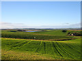
The Meikle Loch
Autumn in Aberdeenshire with the Meikle Loch and Bennachie in the distance
Image: © Martyn Gorman
Taken: 28 Oct 2006
0.23 miles
5
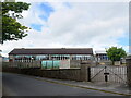
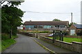
Slains Primary School
The remote school, just off the A975 road, has a pupil roll of 28 in 2020-21 taught in two composite classes, most of whom probably come from the coastal village of Collieston, a couple of km to the south.
Image: © Bill Harrison
Taken: 13 Jun 2021
0.24 miles