IMAGES TAKEN NEAR TO
Collieston, ELLON, AB41 8RX
Introduction
This page details the photographs taken nearby to AB41 8RX by members of the Geograph project.
The Geograph project started in 2005 with the aim of publishing, organising and preserving representative images for every square kilometre of Great Britain, Ireland and the Isle of Man.

There are currently over 7.5m images from over14,400 individuals and you can help contribute to the project by visiting https://www.geograph.org.uk
Image Map
Images are licensed for reuse under creativecommons.org/licenses/by-sa/2.0
Notes
- Clicking on the map will re-center to the selected point.
- The higher the marker number, the further away the image location is from the centre of the postcode.
Image Listing (8 Images Found)
Images are licensed for reuse under creativecommons.org/licenses/by-sa/2.0
Image
Details
Distance
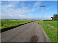
2
Cotehill
The name of this small loch and the house above it.
Image: © Jonathan Billinger
Taken: 17 Jul 2007
0.06 miles
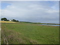
4
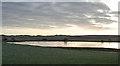
Cotehill Loch
Our hopes of seeing some interesting birdlife on Cotehill Loch were dashed because the whole of the surface was frozen.
Image: © Anne Burgess
Taken: 3 Jan 2019
0.09 miles
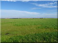
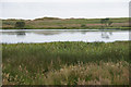
6
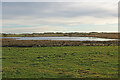
Cotehill Loch
This small shallow loch among the sand dunes is a regular stop for birders, though there were only a few species in evidence today.
Image: © Anne Burgess
Taken: 30 Dec 2021
0.10 miles