IMAGES TAKEN NEAR TO
Collieston, ELLON, AB41 8RT
Introduction
This page details the photographs taken nearby to AB41 8RT by members of the Geograph project.
The Geograph project started in 2005 with the aim of publishing, organising and preserving representative images for every square kilometre of Great Britain, Ireland and the Isle of Man.

There are currently over 7.5m images from over14,400 individuals and you can help contribute to the project by visiting https://www.geograph.org.uk
Image Map
Images are licensed for reuse under creativecommons.org/licenses/by-sa/2.0
Notes
- Clicking on the map will re-center to the selected point.
- The higher the marker number, the further away the image location is from the centre of the postcode.
Image Listing (91 Images Found)
Images are licensed for reuse under creativecommons.org/licenses/by-sa/2.0
Image
Details
Distance
4
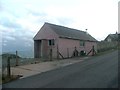
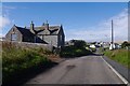
Collieston telephone exchange
Collieston has a pink telephone exchange in a prominent location at the edge of the village.
Image: © Haworth Hodgkinson
Taken: 11 Oct 2016
0.06 miles
5
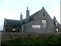
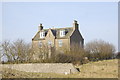
Collieston Community Centre
The Community Centre occupies what I presume to be an old school building.
Image: © Haworth Hodgkinson
Taken: 11 Oct 2016
0.06 miles
6
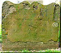
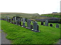
The gravestone of Philip Kennedy in Slains Kirkyard.
With many sea caves in the surrounding cliffs, and with small coves and shingle beaches, Collieston was excellent territory for smugglers. In the late 1700s it was estimated by the Excise that up to 8000 gallons of foreign spirits were being illegally landed in the area every month.
This all came to a head on 17 December 1798. Excisemen lying in wait surprised a group of smugglers unloading their barrels of spirit. In the skirmish that followed the most notorious of the smugglers, Phillip Kennedy, was felled by a blow from an exciseman's cutlass. He died shortly afterwards on a settle in the kitchen of Slains Farm, adjacent to the kirkyard.
Image: © Martyn Gorman
Taken: 5 Apr 2007
0.07 miles
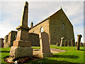
8
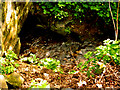
St Ternan's well, Slains Parish Church Kirkyard, Collieston
The spring at the edge of Slains Kirkyard is known as St. Ternan's Well. There was once an iron cup chained to the wall which the parishioners used to take a suppie of water on their way to the kirk on a Sunday morning. As far as can be made out this disappeared shortly before the Second World War.
Image: © Martyn Gorman
Taken: 22 Apr 2007
0.07 miles
9
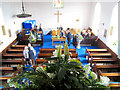
Slains Church celebrates 200 years
On June 29th 2007 Slains Church at Collieston celebrated 200 years of the opening of the "new" church. There was an exhibition of the history of the church in the church itself and teas were served in an adjacent marquee.
Image: © Martyn Gorman
Taken: 30 Jun 2007
0.07 miles