IMAGES TAKEN NEAR TO
ELLON, AB41 8RJ
Introduction
This page details the photographs taken nearby to AB41 8RJ by members of the Geograph project.
The Geograph project started in 2005 with the aim of publishing, organising and preserving representative images for every square kilometre of Great Britain, Ireland and the Isle of Man.

There are currently over 7.5m images from over14,400 individuals and you can help contribute to the project by visiting https://www.geograph.org.uk
Image Map
Images are licensed for reuse under creativecommons.org/licenses/by-sa/2.0
Notes
- Clicking on the map will re-center to the selected point.
- The higher the marker number, the further away the image location is from the centre of the postcode.
Image Listing (13 Images Found)
Images are licensed for reuse under creativecommons.org/licenses/by-sa/2.0
Image
Details
Distance
1
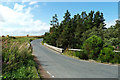
Bridge of Forvie
This bridge crosses the Burn of Forvie just before it enters the Ythan Estuary.
Image: © Mary and Angus Hogg
Taken: 22 Aug 2019
0.05 miles
2
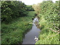
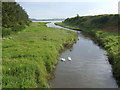
Burn of Forvie
View north - upstream - of the bridge of Forvie
Image: © Jonathan Billinger
Taken: 17 Jul 2007
0.05 miles
3
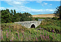
At the Bridge of Forvie
This bridge crosses the Burn of Forvie just before it enters the Ythan Estuary.
Image: © Mary and Angus Hogg
Taken: 22 Aug 2019
0.07 miles
4
Burn of Forvie
Flows into the River Ythan.
View from the Bridge of Forvie.
Image: © JThomas
Taken: 26 Aug 2020
0.09 miles
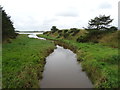
5
Burn of Forvie
The Burn of Forvie viewed from the bridge, heading for the River Ythan.
Image: © Scott Cormie
Taken: 26 Jul 2022
0.11 miles
6
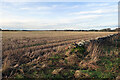
Stubble near Waulkmill
We stopped here to watch a flock of Curlew feeding among the stubble. A neighbouring field was being ploughed, so it probably won't be long before this one too is prepared for the crop of 2022.
Image: © Anne Burgess
Taken: 30 Dec 2021
0.13 miles
7
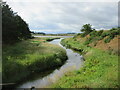
Inlet of the Ythan estuary
This view south of the Forvie bridge shows where the burn of Forvie meets the tidal Ythan estuary - a peaceful scene with a couple of swans.
Image: © Jonathan Billinger
Taken: 17 Jul 2007
0.14 miles
8
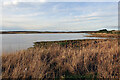
Ythan Estuary
It's close to high tide, and the mudflats are submerged, so there are few birds feeding close to the hide at Waulkmill.
Image: © Anne Burgess
Taken: 30 Dec 2021
0.20 miles
9

Beside the Hide
The Waulkmill hide is at the end of a short track here, but it was so cold and dank inside it and so pleasant in the sunshine outside it that we set up our telescopes outside. The tide was high so the birds were far enough away not to care about us, and it was much warmer in the open. You can just about make them out in the distance, but all the foreground is in this square.
Image: © Anne Burgess
Taken: 3 Jan 2019
0.20 miles
10

Shoreline below Waulkmill
The mouth of the Burn of Forvie.
Image: © Oliver Dixon
Taken: 12 Aug 2023
0.21 miles