IMAGES TAKEN NEAR TO
ELLON, AB41 8RA
Introduction
This page details the photographs taken nearby to AB41 8RA by members of the Geograph project.
The Geograph project started in 2005 with the aim of publishing, organising and preserving representative images for every square kilometre of Great Britain, Ireland and the Isle of Man.

There are currently over 7.5m images from over14,400 individuals and you can help contribute to the project by visiting https://www.geograph.org.uk
Image Map
Images are licensed for reuse under creativecommons.org/licenses/by-sa/2.0
Notes
- Clicking on the map will re-center to the selected point.
- The higher the marker number, the further away the image location is from the centre of the postcode.
Image Listing (4 Images Found)
Images are licensed for reuse under creativecommons.org/licenses/by-sa/2.0
Image
Details
Distance
1
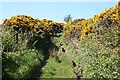
Track or Path?
This is marked as a path on the 1:50,000 map, but as a track on the 1:25,000. I didn't follow it all the way because it was wet underfoot and sometimes the whins were rather close on both sides.
Image: © Anne Burgess
Taken: 11 May 2009
0.06 miles
2
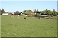
Upper Ardgrain
I am told that Ardgrain Hill is made up of ultramafic rocks, but I did not feel disposed to run the gauntlet of the bull(s?) in this field to check it out. Sometimes hearsay just has to suffice.
Image: © Anne Burgess
Taken: 11 May 2009
0.13 miles
3
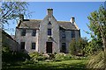
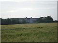
Nether Ardgrain
This is believed to be the oldest house of its kind in Aberdeenshire. Built in 1629 by the Kennedys of Ellon and extended in the 18th century, it is a Grade A listed building. The owner's web site at http://www.ardgrain.com/ardgrain has historical material about Ardgrain. The name is probably Gaelic from 'ard' meaning 'high' and 'grian' meaning 'sun'.
Image: © Anne Burgess
Taken: 11 May 2009
0.18 miles