IMAGES TAKEN NEAR TO
ELLON, AB41 8QE
Introduction
This page details the photographs taken nearby to AB41 8QE by members of the Geograph project.
The Geograph project started in 2005 with the aim of publishing, organising and preserving representative images for every square kilometre of Great Britain, Ireland and the Isle of Man.

There are currently over 7.5m images from over14,400 individuals and you can help contribute to the project by visiting https://www.geograph.org.uk
Image Map
Images are licensed for reuse under creativecommons.org/licenses/by-sa/2.0
Notes
- Clicking on the map will re-center to the selected point.
- The higher the marker number, the further away the image location is from the centre of the postcode.
Image Listing (9 Images Found)
Images are licensed for reuse under creativecommons.org/licenses/by-sa/2.0
Image
Details
Distance
1
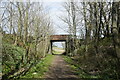
Scene of a disaster
All is quite now on the Formartine and Buchan Way but on 12 March 1874 northbound and southbound Great North of Scotland Railway trains collided head-on about 20 metres south of the occupation bridge that serves Gallowhill of Ellon farm and three railwaymen lost their lives. The accident was apparently caused by one driver misreading the 'working timetable', which specified where trains should stop to safely pass each other on passing loops. See: http://portal.historicenvironment.scot/designation/LB16058 .
Image: © Bill Harrison
Taken: 17 Apr 2021
0.03 miles
2
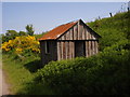
Rail worker hut
Rail workers hut (disused) on the Formartine & Buchan Way
Image: © Derek Gray
Taken: 5 Jun 2008
0.08 miles
3
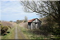
Platelayers hut...
...with Gallowhill of Ellon farmhouse in the background.
Image: © Bill Harrison
Taken: 17 Apr 2021
0.10 miles
4
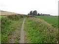
Gallowhill of Ellon
The former Formartine and Buchan railway looking towards Gallowhill of Ellon and in the direction of Ellon which was the next station to the south.
Image: © Richard Webb
Taken: 4 Aug 2011
0.15 miles
5
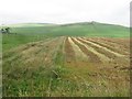
Harvested rape
A near empty agricultural landscape which appears to be a product of drainage work.
Image: © Richard Webb
Taken: 4 Aug 2011
0.22 miles
6
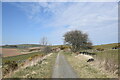
Curve to the right...
...on the Formartine and Buchan Way. The extensive barns of Mains of Drumwhindle can be seen in the distance to the left.
Image: © Bill Harrison
Taken: 17 Apr 2021
0.23 miles
7
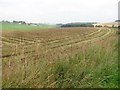
Harvested rape
Oilseed rape straw in a field beside the Formartine and Buchan Way.
Image: © Richard Webb
Taken: 4 Aug 2011
0.24 miles
8
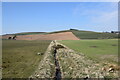
Ditch between fields...
...as seen from the Formartine and Buchan Way. The ditch joins Ebrie Burn (which flows right-to-left) in the distance.
Image: © Bill Harrison
Taken: 17 Apr 2021
0.24 miles
9
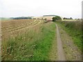
Formartine and Buchan Way
The closed railway's trackbed, now a cycle path and a very enjoyable and wild cycle path passes a harvested field of oilseed rape at Arnage.
Image: © Richard Webb
Taken: 4 Aug 2011
0.25 miles