IMAGES TAKEN NEAR TO
ELLON, AB41 8PZ
Introduction
This page details the photographs taken nearby to AB41 8PZ by members of the Geograph project.
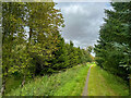
The Geograph project started in 2005 with the aim of publishing, organising and preserving representative images for every square kilometre of Great Britain, Ireland and the Isle of Man.

There are currently over 7.5m images from over14,400 individuals and you can help contribute to the project by visiting https://www.geograph.org.uk
Image Map
Images are licensed for reuse under creativecommons.org/licenses/by-sa/2.0
Notes
- Clicking on the map will re-center to the selected point.
- The higher the marker number, the further away the image location is from the centre of the postcode.
Image Listing (15 Images Found)
Images are licensed for reuse under creativecommons.org/licenses/by-sa/2.0
Image
Details
Distance
2
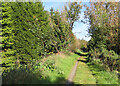
Near Mill of Towie
The old Mill of Towie is on the right but unphotographable from the line of the Formartine and Buchan Way. This section is quite well wooded.
Image: © Anne Burgess
Taken: 3 Oct 2024
0.04 miles
3
Formartine & Buchan Way Approaching Mill of Towie
Many old mills in the north-east were used for grinding (oat)meal. This one is by the Ebrie Burn.
Image: © Colin Smith
Taken: 7 Apr 2007
0.06 miles
4
Former Railway Line
The trackbed here passes between two different lots of planted woodland. On the right, assorted conifers amnd bushes, and on the left a row of poplars.
Image: © Anne Burgess
Taken: 3 Oct 2024
0.06 miles
5
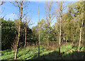
Spindly Trees
I think these are some sort of Poplar, planted in wet ground beside the Ebrie Burn.
Image: © Anne Burgess
Taken: 3 Oct 2024
0.09 miles
6
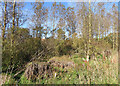
Poplar Woods
These are some sort of Poplar, and they seem to be in rather disturbed ground.
Image: © Anne Burgess
Taken: 3 Oct 2024
0.10 miles
7
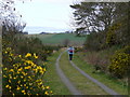
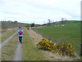
Formartine & Buchan Way near Waulkmill of Savoch
Passing the Ebrie Burn heading north towards Auchnagatt.
Image: © Colin Smith
Taken: 7 Apr 2007
0.17 miles
8
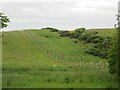
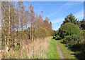
New plantation
Trees planted west of the Ebrie Burn near the Mill of Towie.
Image: © Scott Cormie
Taken: 21 Jun 2024
0.18 miles
9
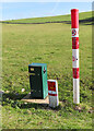
Gas Pipeline Marker
The marker is to allow the pipleine to be easily found, and also to warn against digging anywhere nearby.
Image: © Anne Burgess
Taken: 3 Oct 2024
0.18 miles
10
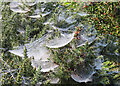
Cobwebs
Some of the thousands of cobwebs alongside the path, picked out by dew that will soon dry out now that the sun is on it.
Image: © Anne Burgess
Taken: 3 Oct 2024
0.18 miles