IMAGES TAKEN NEAR TO
Kinharrachie, ELLON, AB41 8PP
Introduction
This page details the photographs taken nearby to AB41 8PP by members of the Geograph project.
The Geograph project started in 2005 with the aim of publishing, organising and preserving representative images for every square kilometre of Great Britain, Ireland and the Isle of Man.

There are currently over 7.5m images from over14,400 individuals and you can help contribute to the project by visiting https://www.geograph.org.uk
Image Map
Images are licensed for reuse under creativecommons.org/licenses/by-sa/2.0
Notes
- Clicking on the map will re-center to the selected point.
- The higher the marker number, the further away the image location is from the centre of the postcode.
Image Listing (5 Images Found)
Images are licensed for reuse under creativecommons.org/licenses/by-sa/2.0
Image
Details
Distance
1
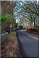
B9005 at Kinharrachie
The B9005, as seen from just beyond the junction at Kinharrachie. The village of Ythanbank is approximately 2.5 miles further down the road in Image
Image: © Alex Silver
Taken: 23 Dec 2011
0.02 miles
2
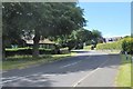
Methlick Road
The B9005 at Kinharrachie leading north-west to Methlick.
Image: © Andrew Wood
Taken: 18 Jul 2020
0.04 miles
3
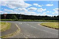
Give Way by Kinharrachie
The Road junction at Kinharrachie with the B9005 joining the Tarves road. Esslemont woods are in the distance.
Image: © Andrew Wood
Taken: 18 Jul 2020
0.09 miles
4
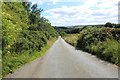
Down Plodhill Brae
Looking down Plodhill with woodland on the left and the B9005 Methlick at the bottom.
Image: © Andrew Wood
Taken: 18 Jul 2020
0.21 miles
5
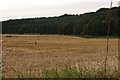
Kinharrachie Fields
Kinharrachie stubble field ,complete with pheasant, and beyond Esslemont woods.
Image: © Andrew Wood
Taken: 12 Oct 2008
0.23 miles