IMAGES TAKEN NEAR TO
ELLON, AB41 8PG
Introduction
This page details the photographs taken nearby to AB41 8PG by members of the Geograph project.
The Geograph project started in 2005 with the aim of publishing, organising and preserving representative images for every square kilometre of Great Britain, Ireland and the Isle of Man.

There are currently over 7.5m images from over14,400 individuals and you can help contribute to the project by visiting https://www.geograph.org.uk
Image Map
Images are licensed for reuse under creativecommons.org/licenses/by-sa/2.0
Notes
- Clicking on the map will re-center to the selected point.
- The higher the marker number, the further away the image location is from the centre of the postcode.
Image Listing (7 Images Found)
Images are licensed for reuse under creativecommons.org/licenses/by-sa/2.0
Image
Details
Distance
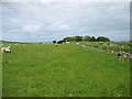
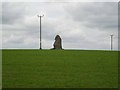
2

Candle Stone
A large whinstone standing stone about 10ft high sitting atop a crest.
Image: © Andrew Wood
Taken: 1 Oct 2016
0.06 miles
3
The Candle Stone
View over Candle Stone looking South
Image: © Ewen Rennie
Taken: Unknown
0.07 miles
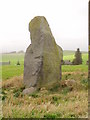
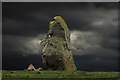
4
The Candle Stone
A megalithic standing stone overlooking the valley of the Ebrie Burn.
Image: © Oliver Dixon
Taken: 23 May 2008
0.07 miles
5
Drumwhindle: The Candle Stane
The Candle Stane, a Neolithic or Bronze Age standing stone some 3.1 metres in height.
Image: © Martyn Gorman
Taken: 10 Mar 2012
0.08 miles