IMAGES TAKEN NEAR TO
ELLON, AB41 8NW
Introduction
This page details the photographs taken nearby to AB41 8NW by members of the Geograph project.
The Geograph project started in 2005 with the aim of publishing, organising and preserving representative images for every square kilometre of Great Britain, Ireland and the Isle of Man.

There are currently over 7.5m images from over14,400 individuals and you can help contribute to the project by visiting https://www.geograph.org.uk
Image Map
Images are licensed for reuse under creativecommons.org/licenses/by-sa/2.0
Notes
- Clicking on the map will re-center to the selected point.
- The higher the marker number, the further away the image location is from the centre of the postcode.
Image Listing (6 Images Found)
Images are licensed for reuse under creativecommons.org/licenses/by-sa/2.0
Image
Details
Distance
1
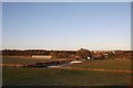
Meiklemill Farm
Now converted into a mini industrial site Meiklemill was once an arable farm on the Esslemont Estate,a large part of its farmland was lost to housing development of the east side of the rail embankment.
Image: © Andrew Wood
Taken: 9 Jan 2011
0.04 miles
2
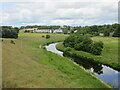
River Ythan
The River Ythan upstream, viewed from the old railway bridge.
Image: © Scott Cormie
Taken: 18 Jul 2023
0.16 miles
3
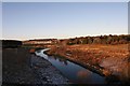
River Ythan from the Bridge
Taken from an old rail bridge over the Ythan this is a westerly view with Meiklemill Woods on the left and housing at Esslemont Circle in Auchterellon on the right.
Image: © Andrew Wood
Taken: 9 Jan 2011
0.16 miles
4
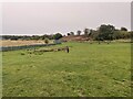
Let Em Aff Dog park
Dog play park in Ellon
Image: © Ralph Greig
Taken: 28 Sep 2023
0.19 miles
5
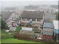
Western Avenue, Ellon
Ellon has expanded as far as the old railway. View from an embankment south of the viaduct.
Image: © Richard Webb
Taken: 4 Aug 2011
0.24 miles
6
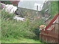
Prowlin'
Disused railways are very interesting places for cats. Housing up against the embankment on the approach to the viaduct.
Image: © Richard Webb
Taken: 4 Aug 2011
0.25 miles