IMAGES TAKEN NEAR TO
ELLON, AB41 8NU
Introduction
This page details the photographs taken nearby to AB41 8NU by members of the Geograph project.
The Geograph project started in 2005 with the aim of publishing, organising and preserving representative images for every square kilometre of Great Britain, Ireland and the Isle of Man.

There are currently over 7.5m images from over14,400 individuals and you can help contribute to the project by visiting https://www.geograph.org.uk
Image Map
Images are licensed for reuse under creativecommons.org/licenses/by-sa/2.0
Notes
- Clicking on the map will re-center to the selected point.
- The higher the marker number, the further away the image location is from the centre of the postcode.
Image Listing (2 Images Found)
Images are licensed for reuse under creativecommons.org/licenses/by-sa/2.0
Image
Details
Distance
1
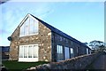
Ulaw Farm
Once a busy working farm, now another housing conversion.
Image: © Andrew Wood
Taken: 16 Oct 2008
0.21 miles
2
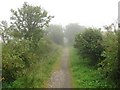
Formartine and Buchan Way
An embankment, south of the Ellon Viaduct.
The Formartine and Buchan Railway is now a 80km path between Fraserburgh, Peterhead and Aberdeen. The railway closed in 1979 and was last used as part of the North Sea oil development, moving material up to Fraserburgh.
Image: © Richard Webb
Taken: 4 Aug 2011
0.24 miles