IMAGES TAKEN NEAR TO
ELLON, AB41 8NR
Introduction
This page details the photographs taken nearby to AB41 8NR by members of the Geograph project.
The Geograph project started in 2005 with the aim of publishing, organising and preserving representative images for every square kilometre of Great Britain, Ireland and the Isle of Man.

There are currently over 7.5m images from over14,400 individuals and you can help contribute to the project by visiting https://www.geograph.org.uk
Image Map
Images are licensed for reuse under creativecommons.org/licenses/by-sa/2.0
Notes
- Clicking on the map will re-center to the selected point.
- The higher the marker number, the further away the image location is from the centre of the postcode.
Image Listing (3 Images Found)
Images are licensed for reuse under creativecommons.org/licenses/by-sa/2.0
Image
Details
Distance
1
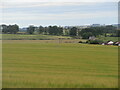
Hillhead of Fechil Trig Pillar
The triangulation pillar just visible in the middle of a field of barley at Hillhead of Fechil.
Image: © Scott Cormie
Taken: 18 Jul 2023
0.13 miles
2
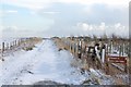
Footpath to Hillies View
The 1350m on the sign looks impressively high - but it's just the distance to the viewpoint...
Image: © John Allan
Taken: 6 Feb 2007
0.21 miles
3
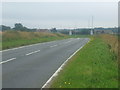
Entering Ellon
Link to local web site - http://www.visitellon.co.uk/index2.html
Image: © Ken Fitlike
Taken: 21 Aug 2007
0.23 miles