IMAGES TAKEN NEAR TO
ELLON, AB41 8ND
Introduction
This page details the photographs taken nearby to AB41 8ND by members of the Geograph project.
The Geograph project started in 2005 with the aim of publishing, organising and preserving representative images for every square kilometre of Great Britain, Ireland and the Isle of Man.

There are currently over 7.5m images from over14,400 individuals and you can help contribute to the project by visiting https://www.geograph.org.uk
Image Map
Images are licensed for reuse under creativecommons.org/licenses/by-sa/2.0
Notes
- Clicking on the map will re-center to the selected point.
- The higher the marker number, the further away the image location is from the centre of the postcode.
Image Listing (7 Images Found)
Images are licensed for reuse under creativecommons.org/licenses/by-sa/2.0
Image
Details
Distance
3
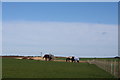
Cross Stone Horses
Horses grazing in a field by Cross Stone farm.
Image: © Andrew Wood
Taken: 2 Apr 2011
0.12 miles
4
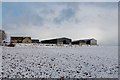
Cross Stone Cottages
Old ruined cottages by Cross Stone, now derelict these were certainly occupied in the early 70's.
Image: © Andrew Wood
Taken: 2 Apr 2011
0.14 miles
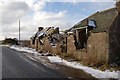
5

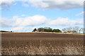
Roadside ruin
Dilapidated cottage by the side of the road near Cross Stone south of Ellon.
Image: © Scott Cormie
Taken: 18 Jul 2023
0.18 miles
7
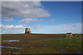
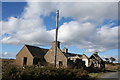
Water Tower
A water storage tower by Cross Stone.
Image: © Andrew Wood
Taken: 2 Apr 2011
0.24 miles