IMAGES TAKEN NEAR TO
ELLON, AB41 8NB
Introduction
This page details the photographs taken nearby to AB41 8NB by members of the Geograph project.
The Geograph project started in 2005 with the aim of publishing, organising and preserving representative images for every square kilometre of Great Britain, Ireland and the Isle of Man.

There are currently over 7.5m images from over14,400 individuals and you can help contribute to the project by visiting https://www.geograph.org.uk
Image Map
Images are licensed for reuse under creativecommons.org/licenses/by-sa/2.0
Notes
- Clicking on the map will re-center to the selected point.
- The higher the marker number, the further away the image location is from the centre of the postcode.
Image Listing (5 Images Found)
Images are licensed for reuse under creativecommons.org/licenses/by-sa/2.0
Image
Details
Distance
1
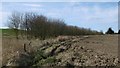
Wood, Mill of Rannieston
Planted between a couple of deep ditches. Much of the farmland here has been drained.
Image: © Richard Webb
Taken: 6 Apr 2017
0.10 miles
2
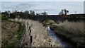
Tarty Burn, Kinknockie
Very much dug out to improve drainage.
Image: © Richard Webb
Taken: 6 Apr 2017
0.16 miles
4
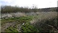
Young woodland, Kinknochie
A recently planted up former farm.
Image: © Richard Webb
Taken: 6 Apr 2017
0.20 miles
5
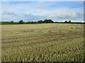
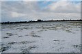
Harvested field
Harvested field to the south of the B9000.
Image: © Scott Cormie
Taken: 18 Jul 2023
0.20 miles