IMAGES TAKEN NEAR TO
ELLON, AB41 8LA
Introduction
This page details the photographs taken nearby to AB41 8LA by members of the Geograph project.
The Geograph project started in 2005 with the aim of publishing, organising and preserving representative images for every square kilometre of Great Britain, Ireland and the Isle of Man.

There are currently over 7.5m images from over14,400 individuals and you can help contribute to the project by visiting https://www.geograph.org.uk
Image Map
Images are licensed for reuse under creativecommons.org/licenses/by-sa/2.0
Notes
- Clicking on the map will re-center to the selected point.
- The higher the marker number, the further away the image location is from the centre of the postcode.
Image Listing (8 Images Found)
Images are licensed for reuse under creativecommons.org/licenses/by-sa/2.0
Image
Details
Distance
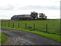
3
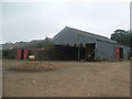
Mains of Leask
Most of these farm buildings date from 'the days of the horse' - before the giant industrial unit style sheds of more recent times.
Image: © Ken Fitlike
Taken: 21 Aug 2007
0.11 miles
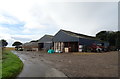
4
Mains of Leask
Farmhouse sheltered by trees with a south facing gap to make the most of any sun that may shine in this bleak corner of north-east Scotland.
Image: © Ken Fitlike
Taken: 21 Aug 2007
0.12 miles
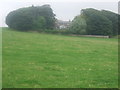
8
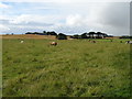
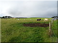
Grazing near Mains of Leask
Towards Knapsleask.
Image: © JThomas
Taken: 23 Aug 2020
0.24 miles