IMAGES TAKEN NEAR TO
ELLON, AB41 8JX
Introduction
This page details the photographs taken nearby to AB41 8JX by members of the Geograph project.
The Geograph project started in 2005 with the aim of publishing, organising and preserving representative images for every square kilometre of Great Britain, Ireland and the Isle of Man.

There are currently over 7.5m images from over14,400 individuals and you can help contribute to the project by visiting https://www.geograph.org.uk
Image Map
Images are licensed for reuse under creativecommons.org/licenses/by-sa/2.0
Notes
- Clicking on the map will re-center to the selected point.
- The higher the marker number, the further away the image location is from the centre of the postcode.
Image Listing (2 Images Found)
Images are licensed for reuse under creativecommons.org/licenses/by-sa/2.0
Image
Details
Distance
1
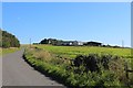
Hillhead Farm
The farm steading of Hillhead with the road sweeping up to it. The farmhouse sits in the next square.
Image: © Andrew Wood
Taken: 31 Aug 2020
0.04 miles
2
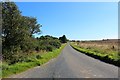
Pitlurg Dogleg
Seen here mostly as a straight this is in fact a dogleg, avoiding the redundant railway line it crosses at the end near Pitlurg Station House.
Image: © Andrew Wood
Taken: 31 Aug 2020
0.23 miles