IMAGES TAKEN NEAR TO
ELLON, AB41 8EG
Introduction
This page details the photographs taken nearby to AB41 8EG by members of the Geograph project.
The Geograph project started in 2005 with the aim of publishing, organising and preserving representative images for every square kilometre of Great Britain, Ireland and the Isle of Man.

There are currently over 7.5m images from over14,400 individuals and you can help contribute to the project by visiting https://www.geograph.org.uk
Image Map
Images are licensed for reuse under creativecommons.org/licenses/by-sa/2.0
Notes
- Clicking on the map will re-center to the selected point.
- The higher the marker number, the further away the image location is from the centre of the postcode.
Image Listing (3 Images Found)
Images are licensed for reuse under creativecommons.org/licenses/by-sa/2.0
Image
Details
Distance
1
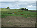
Farmland at Ardganty
...with Scotston in view at top in hill
Image: © Ken Fitlike
Taken: 20 May 2007
0.09 miles
2
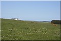
Brown Hill
The site of this large house is shown on the 1:50,000 map as having no access road, so I surmise that it is on the site of a building which had long been abandoned. The 1:25,000 map shows an access from the north, near Arganty.
Image: © Anne Burgess
Taken: 11 May 2009
0.20 miles
3
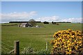
New House Near Ardganty
Sunnyside, uphill beyond the new house, is still in square, but the top of the Hill of Dudwick, including the 'golf ball', is in the next square
Image: © Anne Burgess
Taken: 11 May 2009
0.23 miles