IMAGES TAKEN NEAR TO
ELLON, AB41 8DR
Introduction
This page details the photographs taken nearby to AB41 8DR by members of the Geograph project.
The Geograph project started in 2005 with the aim of publishing, organising and preserving representative images for every square kilometre of Great Britain, Ireland and the Isle of Man.

There are currently over 7.5m images from over14,400 individuals and you can help contribute to the project by visiting https://www.geograph.org.uk
Image Map
Images are licensed for reuse under creativecommons.org/licenses/by-sa/2.0
Notes
- Clicking on the map will re-center to the selected point.
- The higher the marker number, the further away the image location is from the centre of the postcode.
Image Listing (4 Images Found)
Images are licensed for reuse under creativecommons.org/licenses/by-sa/2.0
Image
Details
Distance
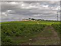
2

Plodhill Pylon
A power pylon in a clear break between conifer plantations at Plodhill.
Image: © Andrew Wood
Taken: 18 Jul 2020
0.17 miles
3
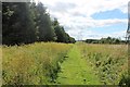
Pylon Path
A newly mown path through grass by the pylon line on Plodhill.
Image: © Andrew Wood
Taken: 18 Jul 2020
0.22 miles
4
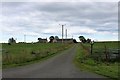
Loch-hills Farm
A small farm near Plodhill Wood.
Image: © Andrew Wood
Taken: 18 Jul 2020
0.24 miles