IMAGES TAKEN NEAR TO
ELLON, AB41 8DE
Introduction
This page details the photographs taken nearby to AB41 8DE by members of the Geograph project.
The Geograph project started in 2005 with the aim of publishing, organising and preserving representative images for every square kilometre of Great Britain, Ireland and the Isle of Man.

There are currently over 7.5m images from over14,400 individuals and you can help contribute to the project by visiting https://www.geograph.org.uk
Image Map
Images are licensed for reuse under creativecommons.org/licenses/by-sa/2.0
Notes
- Clicking on the map will re-center to the selected point.
- The higher the marker number, the further away the image location is from the centre of the postcode.
Image Listing (7 Images Found)
Images are licensed for reuse under creativecommons.org/licenses/by-sa/2.0
Image
Details
Distance
1
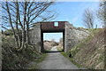
Occupation bridge for Wardhead Farm...
...over the Formartine and Buchan Way.
Image: © Bill Harrison
Taken: 17 Apr 2021
0.10 miles
2
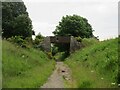
Bridge at Wardhead
Bridge over the Formartine & Buchan Way at Wardhead, north-west of Ellon.
Image: © Scott Cormie
Taken: 21 Jun 2024
0.10 miles
3
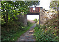
Accommodation Bridge
This one is at Wardhead Farm. It's looking very much the worse for wear, with part of its iron parapet missing, and the rest looking rather insecure.
Image: © Anne Burgess
Taken: 3 Oct 2024
0.10 miles
4
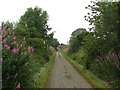
Formartine and Buchan Way
A bridge over a cutting at Wardhead. The railway closed in 1979 having played a part in developing some of the North Sea oil fields. It is now an 80km cycle path.
Image: © Richard Webb
Taken: 4 Aug 2011
0.11 miles
5
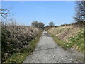
The Formartine and Buchan Way...
...just north of Ellon.
Image: © Bill Harrison
Taken: 17 Apr 2021
0.12 miles
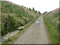
6

Formartine and Buchan Way
The trackbed north of Ellon has a good wide riding surface, for a while. This cutting, like most of the cuttings on the old railway is full of rosebay willowherb.
Image: © Richard Webb
Taken: 4 Aug 2011
0.15 miles
7
Formartine and Buchan Way
The old railway trackbed is now a cycle path and is also used for routing utilities.
Image: © Richard Webb
Taken: 4 Aug 2011
0.22 miles