IMAGES TAKEN NEAR TO
Udny, ELLON, AB41 7RP
Introduction
This page details the photographs taken nearby to AB41 7RP by members of the Geograph project.
The Geograph project started in 2005 with the aim of publishing, organising and preserving representative images for every square kilometre of Great Britain, Ireland and the Isle of Man.

There are currently over 7.5m images from over14,400 individuals and you can help contribute to the project by visiting https://www.geograph.org.uk
Image Map
Images are licensed for reuse under creativecommons.org/licenses/by-sa/2.0
Notes
- Clicking on the map will re-center to the selected point.
- The higher the marker number, the further away the image location is from the centre of the postcode.
Image Listing (5 Images Found)
Images are licensed for reuse under creativecommons.org/licenses/by-sa/2.0
Image
Details
Distance
1
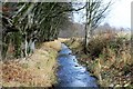
Tarty Burn
The Tarty Burn flowing past sheltering woodland near Rosebank Farm.
Image: © Andrew Wood
Taken: 4 Dec 2016
0.08 miles
2
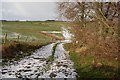
Track across the burn
Just south of Rosebank Farm.
Image: © John Allan
Taken: 6 Feb 2007
0.10 miles
3
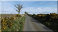
Towards Rosebank
The trees contrast with the wide open spaces here.
Image: © Richard Webb
Taken: 6 Apr 2017
0.17 miles
4
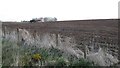
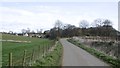
Blackhillie
Probably spring barley going in.
Image: © Richard Webb
Taken: 6 Apr 2017
0.18 miles