IMAGES TAKEN NEAR TO
Udny, ELLON, AB41 7RL
Introduction
This page details the photographs taken nearby to AB41 7RL by members of the Geograph project.
The Geograph project started in 2005 with the aim of publishing, organising and preserving representative images for every square kilometre of Great Britain, Ireland and the Isle of Man.

There are currently over 7.5m images from over14,400 individuals and you can help contribute to the project by visiting https://www.geograph.org.uk
Image Map
Images are licensed for reuse under creativecommons.org/licenses/by-sa/2.0
Notes
- Clicking on the map will re-center to the selected point.
- The higher the marker number, the further away the image location is from the centre of the postcode.
Image Listing (4 Images Found)
Images are licensed for reuse under creativecommons.org/licenses/by-sa/2.0
Image
Details
Distance
1
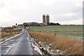
Kinknockie Farm
Sitting slightly high in a fairly flat area, and with its twin silos, this is a clear landmark for miles around.
Image: © John Allan
Taken: 6 Feb 2007
0.01 miles
2
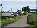
Cottages at Kinknockie
Roadside white-washed cottages at Kinknockie.
Image: © Scott Cormie
Taken: 18 Jul 2023
0.05 miles
3
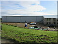
New factory at Kinknockie
New facility for timber frames unit opposite Kinknockie Farm.
Image: © Scott Cormie
Taken: 18 Jul 2023
0.10 miles