IMAGES TAKEN NEAR TO
Udny, ELLON, AB41 7PR
Introduction
This page details the photographs taken nearby to AB41 7PR by members of the Geograph project.
The Geograph project started in 2005 with the aim of publishing, organising and preserving representative images for every square kilometre of Great Britain, Ireland and the Isle of Man.

There are currently over 7.5m images from over14,400 individuals and you can help contribute to the project by visiting https://www.geograph.org.uk
Image Map
Images are licensed for reuse under creativecommons.org/licenses/by-sa/2.0
Notes
- Clicking on the map will re-center to the selected point.
- The higher the marker number, the further away the image location is from the centre of the postcode.
Image Listing (7 Images Found)
Images are licensed for reuse under creativecommons.org/licenses/by-sa/2.0
Image
Details
Distance
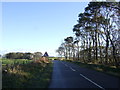
1
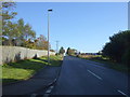
Track to Mill of Allathan
North off the B9000.
Image: © JThomas
Taken: 10 Nov 2013
0.14 miles
3
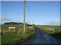
Mill of Allathan
Unusually, Mill of Allathan is located, not as one might expect beside a burn, but close to the summit of the hill.
Image: © Anne Burgess
Taken: 27 Nov 2008
0.17 miles
4
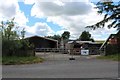
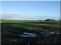
Wood Recyclability
A wood recycling and social needs centre built upon the site of Cloisterseat Croft.
Image: © Andrew Wood
Taken: 19 Jul 2020
0.18 miles
6
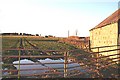
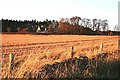
Looking towards Mill of Allathan
The sunset catches a wall of the farm buildings at Allathan.
Image: © Anne Burgess
Taken: 27 Nov 2008
0.20 miles