IMAGES TAKEN NEAR TO
Old Aberdeen Road, ELLON, AB41 7PG
Introduction
This page details the photographs taken nearby to Old Aberdeen Road, AB41 7PG by members of the Geograph project.
The Geograph project started in 2005 with the aim of publishing, organising and preserving representative images for every square kilometre of Great Britain, Ireland and the Isle of Man.

There are currently over 7.5m images from over14,400 individuals and you can help contribute to the project by visiting https://www.geograph.org.uk
Image Map
Images are licensed for reuse under creativecommons.org/licenses/by-sa/2.0
Notes
- Clicking on the map will re-center to the selected point.
- The higher the marker number, the further away the image location is from the centre of the postcode.
Image Listing (29 Images Found)
Images are licensed for reuse under creativecommons.org/licenses/by-sa/2.0
Image
Details
Distance
1
Bede Way
Modern housing on the outskirts of Tarves.
Image: © Anne Burgess
Taken: 19 Sep 2008
0.02 miles
2
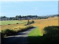
Winding Road to Tarves
The Old Aberdeen Road leading into Tarves. This road predates the turnpike road and was used as a drove road.
Image: © Andrew Wood
Taken: 28 Jul 2018
0.07 miles
3
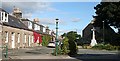
The Square, Tarves
Centre of the Aberdeenshire village of Tarves. The Aberdeen Arms in the background was a traditional coaching inn.
Image: © phil smith
Taken: 24 May 2005
0.14 miles
4
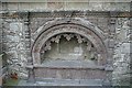
The Tolquhon Tomb
This is a carefully protected monument in the kirkyard of Tarves, in what was the aisle of the mediaeval kirk. It was erected in 1589 by William Forbes, 7th Laird of Tolquhon, to commemorate himself and his wife Elizabeth Gordon, daughter to Gordon of Lesmoir. William Forbes died in 1596.
Image: © Anne Burgess
Taken: 19 Sep 2008
0.14 miles
5
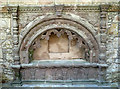
The Tolquhon Tomb at Tarves
This impressive tomb marks the burial place of William Forbes, 7th Lord of Tolquhon, and his wife, Elizabeth Gordon. Lord Tolquhon died in 1596.
Top left, there’s a shield showing the arms of Forbes; on the other side, there’s a shield showing the arms of Lesmoir, his wife’s family. This shield is impaled with the arms of Forbes. Six running dogs adorn the arch, with a skull and crossed bones on the base, representing man’s mortality. On either side of the arch, there are small statues of Lord and Lady Tolquhon.
Maintained by Historic Environment Scotland, visitors are invited to take part in Citizen Science by submitting photographs of the tomb to Monument Monitor. This is to facilitate assessment levels of water damage. For a 2008 view, see Image
Image: © Mary and Angus Hogg
Taken: 22 Aug 2019
0.14 miles
6
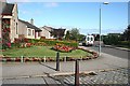
The Square
The middle of the square has been landscaped and planted, providing parking without detracting too much from the townscape. Even better, it almost hides the bus shelter.
Image: © Anne Burgess
Taken: 19 Sep 2008
0.14 miles
7
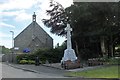
War Memorial
Tarves war memorial by the church on Kirk Brae.
Image: © Andrew Wood
Taken: 17 Jun 2018
0.14 miles
8
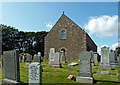
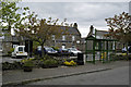
Tarves Parish Church
The church and graveyard in Tarves village.
Image: © Mary and Angus Hogg
Taken: 22 Aug 2019
0.15 miles
9
Kirk Brae
Once a road out of the village, this is now a quite cul-de-sac by the kirk.
Image: © Anne Burgess
Taken: 19 Sep 2008
0.15 miles
10
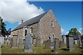
Tarves Kirk
Built in 1798 in "preaching-box" style (a simple rectangular floor-plan) to replace a medieval church that had fallen into ruin. B-listed: http://data.historic-scotland.gov.uk/pls/htmldb/f?p=2200:15:0::::BUILDING:16004 .
Image: © Bill Harrison
Taken: 14 Jun 2015
0.15 miles