IMAGES TAKEN NEAR TO
Pitmedden, ELLON, AB41 7PA
Introduction
This page details the photographs taken nearby to AB41 7PA by members of the Geograph project.
The Geograph project started in 2005 with the aim of publishing, organising and preserving representative images for every square kilometre of Great Britain, Ireland and the Isle of Man.

There are currently over 7.5m images from over14,400 individuals and you can help contribute to the project by visiting https://www.geograph.org.uk
Image Map
Images are licensed for reuse under creativecommons.org/licenses/by-sa/2.0
Notes
- Clicking on the map will re-center to the selected point.
- The higher the marker number, the further away the image location is from the centre of the postcode.
Image Listing (8 Images Found)
Images are licensed for reuse under creativecommons.org/licenses/by-sa/2.0
Image
Details
Distance

4

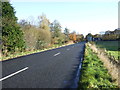
South Mains Avenue
A tree lined path to South Mains from Pitmedden House.
Image: © Andrew Wood
Taken: 14 Mar 2010
0.10 miles

6
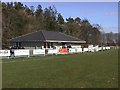
Formartine United Football Clubhouse
Formartine United Football Clubhouse
Image: © Ken Ross
Taken: 30 Aug 2007
0.14 miles
7
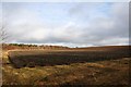
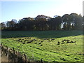
Ploughland at Pitmedden
Newly ploughed field on the outskirts of Pitmedden.
Image: © Andrew Wood
Taken: 14 Mar 2010
0.15 miles
8

Trimming the Parterre Hedging at Pitmedden
A once a year job which requires great skill and patience.
Image: © jamesnicoll
Taken: 26 May 2010
0.20 miles