IMAGES TAKEN NEAR TO
Tarves, ELLON, AB41 7LX
Introduction
This page details the photographs taken nearby to AB41 7LX by members of the Geograph project.
The Geograph project started in 2005 with the aim of publishing, organising and preserving representative images for every square kilometre of Great Britain, Ireland and the Isle of Man.

There are currently over 7.5m images from over14,400 individuals and you can help contribute to the project by visiting https://www.geograph.org.uk
Image Map
Images are licensed for reuse under creativecommons.org/licenses/by-sa/2.0
Notes
- Clicking on the map will re-center to the selected point.
- The higher the marker number, the further away the image location is from the centre of the postcode.
Image Listing (3 Images Found)
Images are licensed for reuse under creativecommons.org/licenses/by-sa/2.0
Image
Details
Distance
1
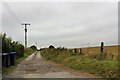
Cairnhill Road
The access road to Cairnhill Farm with the roof of a farm cottage just visible.
Image: © Andrew Wood
Taken: 13 Aug 2020
0.06 miles
2
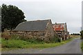
Shethin Smiddy
The old croft buildings at Shethin Smithy.
Image: © Andrew Wood
Taken: 13 Aug 2020
0.14 miles
3
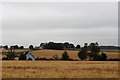
Cairnhill On the Skyline
Cairnhill sits at the top of this photo with fields of barley all around.
Image: © Andrew Wood
Taken: 13 Aug 2020
0.16 miles