IMAGES TAKEN NEAR TO
Tarves, ELLON, AB41 7LT
Introduction
This page details the photographs taken nearby to AB41 7LT by members of the Geograph project.
The Geograph project started in 2005 with the aim of publishing, organising and preserving representative images for every square kilometre of Great Britain, Ireland and the Isle of Man.

There are currently over 7.5m images from over14,400 individuals and you can help contribute to the project by visiting https://www.geograph.org.uk
Image Map
Images are licensed for reuse under creativecommons.org/licenses/by-sa/2.0
Notes
- Clicking on the map will re-center to the selected point.
- The higher the marker number, the further away the image location is from the centre of the postcode.
Image Listing (4 Images Found)
Images are licensed for reuse under creativecommons.org/licenses/by-sa/2.0
Image
Details
Distance
1
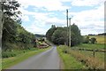
Little Ythsie
A farm on a tight bend as indicated by the road sign. The bend is covered by trees so can catch out the unwary. There is also newbuild housing on the left, obscured by the hedge, behind the fencing.
Image: © Andrew Wood
Taken: 18 Jul 2020
0.01 miles
2
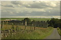
Little Ythsie
A small collection of farm buildings and houses at Little Ythsie
Image: © Steven Brown
Taken: 30 Jul 2007
0.06 miles
3
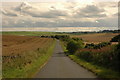
Ythsie
Country road looking in the direction of Little Ythsie
Image: © Steven Brown
Taken: 30 Jul 2007
0.19 miles
4
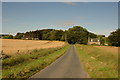
Little Ythsie
Looking north to the settlement at Little Ythsie
Image: © Steven Brown
Taken: 30 Jul 2007
0.19 miles