IMAGES TAKEN NEAR TO
Tarves, ELLON, AB41 7LS
Introduction
This page details the photographs taken nearby to AB41 7LS by members of the Geograph project.
The Geograph project started in 2005 with the aim of publishing, organising and preserving representative images for every square kilometre of Great Britain, Ireland and the Isle of Man.

There are currently over 7.5m images from over14,400 individuals and you can help contribute to the project by visiting https://www.geograph.org.uk
Image Map
Images are licensed for reuse under creativecommons.org/licenses/by-sa/2.0
Notes
- Clicking on the map will re-center to the selected point.
- The higher the marker number, the further away the image location is from the centre of the postcode.
Image Listing (5 Images Found)
Images are licensed for reuse under creativecommons.org/licenses/by-sa/2.0
Image
Details
Distance
1
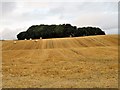
Chapel Fauld
A field to the north of the stone circle at South Ythsie. The trees shelter the farm itself , although part may be visible on close inspection. The ground is gently sloping to the left at both South and North Ythsie sit atop a small hill. Chapel Fauld is an old term for the site which originally included the stone circle as well.
Image: © Andrew Wood
Taken: 3 Aug 2018
0.10 miles
3
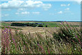
Towards Little Ythsie
A mid-August view from South Ythsie.
Image: © Mary and Angus Hogg
Taken: 22 Aug 2019
0.20 miles
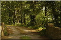
4
Track North to South Ythsie
The trackway to South Ythsie, the path to the stone circle leads left by the signboard.
Image: © Andrew Wood
Taken: 3 Aug 2018
0.20 miles
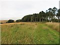
5
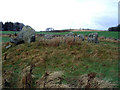
Stone circle and distant view of the Prop of Ythsie.
Six stones forming a circle ca.2000BC.
The Prop of Ythsie, a more recent monument, is seen on the hill on the skyline. It commemorates George Gordon, 4th Earl of Aberdeen and Prime Minister 1852-1855.
Image: © Peter Ward
Taken: 24 Nov 2005
0.22 miles