IMAGES TAKEN NEAR TO
Methlick, ELLON, AB41 7JH
Introduction
This page details the photographs taken nearby to AB41 7JH by members of the Geograph project.
The Geograph project started in 2005 with the aim of publishing, organising and preserving representative images for every square kilometre of Great Britain, Ireland and the Isle of Man.

There are currently over 7.5m images from over14,400 individuals and you can help contribute to the project by visiting https://www.geograph.org.uk
Image Map
Images are licensed for reuse under creativecommons.org/licenses/by-sa/2.0
Notes
- Clicking on the map will re-center to the selected point.
- The higher the marker number, the further away the image location is from the centre of the postcode.
Image Listing (5 Images Found)
Images are licensed for reuse under creativecommons.org/licenses/by-sa/2.0
Image
Details
Distance
1
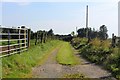
Fore Den
The woodland of Fore Den and the access to Meikle Ardo Croft.
Image: © Andrew Wood
Taken: 31 Jul 2020
0.09 miles
2
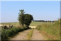
Fordmouth Road
The access to Fordmouth which lies over the hill in the next square north. The pylons and woodland in the distance are on the Hill of Balquhindachy.
Image: © Andrew Wood
Taken: 31 Jul 2020
0.11 miles
3
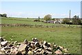
Merdrum
Medrum is the nearest house, and the one beyond it is Merdrum Cottage.
Image: © Anne Burgess
Taken: 14 May 2009
0.13 miles
4
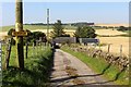
Merdrum Road
The short road downhill to Merdrum.
Image: © Andrew Wood
Taken: 31 Jul 2020
0.13 miles
5

Murrayhill
Murrayhill is on the skyline at left. The dip in the land at extreme left is the Back Den. There is a Fore Den too, out of sight in this view.
Image: © Anne Burgess
Taken: 14 May 2009
0.23 miles