IMAGES TAKEN NEAR TO
Gight, ELLON, AB41 7JB
Introduction
This page details the photographs taken nearby to AB41 7JB by members of the Geograph project.
The Geograph project started in 2005 with the aim of publishing, organising and preserving representative images for every square kilometre of Great Britain, Ireland and the Isle of Man.

There are currently over 7.5m images from over14,400 individuals and you can help contribute to the project by visiting https://www.geograph.org.uk
Image Map
Images are licensed for reuse under creativecommons.org/licenses/by-sa/2.0
Notes
- Clicking on the map will re-center to the selected point.
- The higher the marker number, the further away the image location is from the centre of the postcode.
Image Listing (6 Images Found)
Images are licensed for reuse under creativecommons.org/licenses/by-sa/2.0
Image
Details
Distance
2
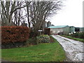
Burnside of Gight
A large mixed farm with extensive outbuildings.
Image: © Anne Burgess
Taken: 14 May 2009
0.03 miles
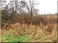
4
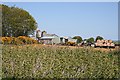
Abandoned Farm Machinery near Burnside of Gight
Image: © Alison Mack
Taken: 4 Jan 2009
0.11 miles
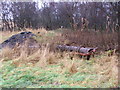
5
Abandoned Farm Machinery near Burnside of Gight
Image: © Alison Mack
Taken: 4 Jan 2009
0.11 miles
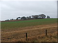
6
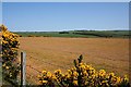
Near Burnside of Gight
The grass in this field is a peculiar brown colour, unlike all the others round about. Surely it can't be that just this one field is suffering from drought?
Image: © Anne Burgess
Taken: 14 May 2009
0.16 miles