IMAGES TAKEN NEAR TO
Methlick, ELLON, AB41 7HH
Introduction
This page details the photographs taken nearby to AB41 7HH by members of the Geograph project.
The Geograph project started in 2005 with the aim of publishing, organising and preserving representative images for every square kilometre of Great Britain, Ireland and the Isle of Man.

There are currently over 7.5m images from over14,400 individuals and you can help contribute to the project by visiting https://www.geograph.org.uk
Image Map
Images are licensed for reuse under creativecommons.org/licenses/by-sa/2.0
Notes
- Clicking on the map will re-center to the selected point.
- The higher the marker number, the further away the image location is from the centre of the postcode.
Image Listing (4 Images Found)
Images are licensed for reuse under creativecommons.org/licenses/by-sa/2.0
Image
Details
Distance
2
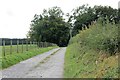
Courtstone Farm Road
The entrance to Courtstone Farm.
Image: © Andrew Wood
Taken: 8 Oct 2016
0.16 miles
3
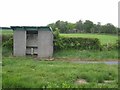
Bus shelter at Courtstone
This sorry-looking bus shelter doesn't appear to get much use. Possibly because, with road re-alignment, it doesn't stand right up to the B9170 Old Meldrum to Methlick road any more. Courtstone farm in the background.
Image: © Oliver Dixon
Taken: 20 May 2008
0.20 miles