IMAGES TAKEN NEAR TO
Methlick, ELLON, AB41 7HE
Introduction
This page details the photographs taken nearby to AB41 7HE by members of the Geograph project.
The Geograph project started in 2005 with the aim of publishing, organising and preserving representative images for every square kilometre of Great Britain, Ireland and the Isle of Man.

There are currently over 7.5m images from over14,400 individuals and you can help contribute to the project by visiting https://www.geograph.org.uk
Image Map
Images are licensed for reuse under creativecommons.org/licenses/by-sa/2.0
Notes
- Clicking on the map will re-center to the selected point.
- The higher the marker number, the further away the image location is from the centre of the postcode.
Image Listing (5 Images Found)
Images are licensed for reuse under creativecommons.org/licenses/by-sa/2.0
Image
Details
Distance
1
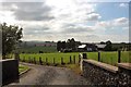
Burnside Paddock
A horse in its paddock by Burnside Croft.
Image: © Andrew Wood
Taken: 19 Aug 2020
0.08 miles
3
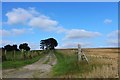
Road to Hillbrae Croft
The road, uphill as befits the name, to Hillbrae Croft.
Image: © Andrew Wood
Taken: 19 Aug 2020
0.12 miles
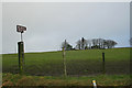
5
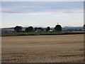
Hillbrae Croft
A distant view of Hillbrae Croft from the north-east, with Mither Tap of Bennachie visible on the horizon to the right.
Image: © Scott Cormie
Taken: 1 Oct 2022
0.14 miles