IMAGES TAKEN NEAR TO
Methlick, ELLON, AB41 7HD
Introduction
This page details the photographs taken nearby to AB41 7HD by members of the Geograph project.
The Geograph project started in 2005 with the aim of publishing, organising and preserving representative images for every square kilometre of Great Britain, Ireland and the Isle of Man.

There are currently over 7.5m images from over14,400 individuals and you can help contribute to the project by visiting https://www.geograph.org.uk
Image Map
Images are licensed for reuse under creativecommons.org/licenses/by-sa/2.0
Notes
- Clicking on the map will re-center to the selected point.
- The higher the marker number, the further away the image location is from the centre of the postcode.
Image Listing (5 Images Found)
Images are licensed for reuse under creativecommons.org/licenses/by-sa/2.0
Image
Details
Distance
1
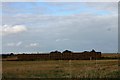
Bales by Braikley
A bale stack by Upper Braikley.
Image: © Andrew Wood
Taken: 8 Oct 2016
0.12 miles
2
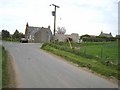
Country crossroads
On the minor road between Crofts of Haddo and Earlsford.
Image: © Oliver Dixon
Taken: 20 May 2008
0.16 miles
3
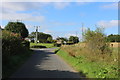
Braiklay Crossroads
Crossroads to the south of Upper Baiklay.
Image: © Andrew Wood
Taken: 19 Aug 2020
0.17 miles
4
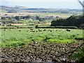
Cattle at Braikley
Looking eastwards to cattle in a field at Braikley.
Image: © Scott Cormie
Taken: 1 Oct 2022
0.19 miles
5
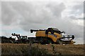
Harvest Over
Their work complete in this field a combine and tractor sit in the corner of a field by the road junction.
Image: © Andrew Wood
Taken: 8 Oct 2016
0.20 miles