IMAGES TAKEN NEAR TO
Methlick, ELLON, AB41 7EN
Introduction
This page details the photographs taken nearby to AB41 7EN by members of the Geograph project.
The Geograph project started in 2005 with the aim of publishing, organising and preserving representative images for every square kilometre of Great Britain, Ireland and the Isle of Man.

There are currently over 7.5m images from over14,400 individuals and you can help contribute to the project by visiting https://www.geograph.org.uk
Image Map
Images are licensed for reuse under creativecommons.org/licenses/by-sa/2.0
Notes
- Clicking on the map will re-center to the selected point.
- The higher the marker number, the further away the image location is from the centre of the postcode.
Image Listing (8 Images Found)
Images are licensed for reuse under creativecommons.org/licenses/by-sa/2.0
Image
Details
Distance
1
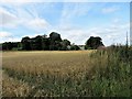
Barley by Kelly
A field of barley and trees with Kelly Sawmill beyond.
Image: © Andrew Wood
Taken: 5 Aug 2018
0.04 miles
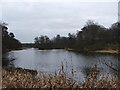
2
Falls of Lady Anna, Haddo Estate
Flow of water from Kelly Lake, close to Sawmill, Haddo Estate.
Image: © Alison Mack
Taken: 2 Jan 2009
0.06 miles
3
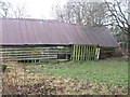
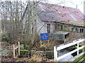
Anglers' Carpark, Kelly Lake, Haddo Estate
The sign on the dilapidated shed indicates that anglers (on close-bye Kelly Lake?) may park here.
Image: © Alison Mack
Taken: 2 Jan 2009
0.06 miles
4
Sign for The Lady Anna Falls, Haddo Estate
Sign is at the top of the falls.
Image: © Alison Mack
Taken: 2 Jan 2009
0.06 miles
5
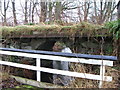
Old Bridge, The Lady Anna Falls, Haddo Estate
Old disused stone bridge, above the falls.
Image: © Alison Mack
Taken: 2 Jan 2009
0.06 miles
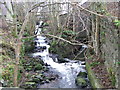
6
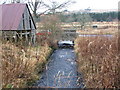
Additional Watercourse, The Lady Anna Falls, Haddo Estate
This looks like it may have been part of the lade for the Haddo Sawmill when it was driven by a water wheel.
Image: © Alison Mack
Taken: 2 Jan 2009
0.06 miles
7
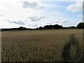
Barley Field
Barley ripening in a field by Haddo Woods.
Image: © Andrew Wood
Taken: 5 Aug 2018
0.10 miles