IMAGES TAKEN NEAR TO
Methlick, ELLON, AB41 7EL
Introduction
This page details the photographs taken nearby to AB41 7EL by members of the Geograph project.
The Geograph project started in 2005 with the aim of publishing, organising and preserving representative images for every square kilometre of Great Britain, Ireland and the Isle of Man.

There are currently over 7.5m images from over14,400 individuals and you can help contribute to the project by visiting https://www.geograph.org.uk
Image Map
Images are licensed for reuse under creativecommons.org/licenses/by-sa/2.0
Notes
- Clicking on the map will re-center to the selected point.
- The higher the marker number, the further away the image location is from the centre of the postcode.
Image Listing (3 Images Found)
Images are licensed for reuse under creativecommons.org/licenses/by-sa/2.0
Image
Details
Distance
2
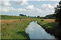
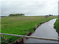
The River Ythan from Forester's Bridge
A downstream view taken in mid-August.
Image: © Mary and Angus Hogg
Taken: 22 Aug 2019
0.17 miles
3
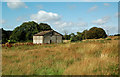
Old building near Forester's Bridge
There are several of these old buildings in this part of the Ythan valley, presumably used for agricultural purposes.
Image: © Mary and Angus Hogg
Taken: 22 Aug 2019
0.25 miles