IMAGES TAKEN NEAR TO
Methlick, ELLON, AB41 7BY
Introduction
This page details the photographs taken nearby to AB41 7BY by members of the Geograph project.
The Geograph project started in 2005 with the aim of publishing, organising and preserving representative images for every square kilometre of Great Britain, Ireland and the Isle of Man.

There are currently over 7.5m images from over14,400 individuals and you can help contribute to the project by visiting https://www.geograph.org.uk
Image Map
Images are licensed for reuse under creativecommons.org/licenses/by-sa/2.0
Notes
- Clicking on the map will re-center to the selected point.
- The higher the marker number, the further away the image location is from the centre of the postcode.
Image Listing (3 Images Found)
Images are licensed for reuse under creativecommons.org/licenses/by-sa/2.0
Image
Details
Distance
1
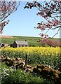
Cottage at Balquhindachy
This is the most picturesque of the three cottages at the end of the public road at Balquhindachy. The farms in the distance are Souterhill, and Peacehaven to the right.
Image: © Anne Burgess
Taken: 14 May 2009
0.01 miles
2
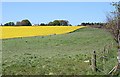
Balquhindachy
The whitewashed farm house at Balquhindachy, well screened by trees, looks out to the south across its fields.
Image: © Anne Burgess
Taken: 14 May 2009
0.15 miles
3
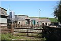
Balquhindachy
Part of the farm yard at Balquindachy. Some of the barns accommodate pigs.
Image: © Anne Burgess
Taken: 14 May 2009
0.16 miles