IMAGES TAKEN NEAR TO
Udny, ELLON, AB41 6ST
Introduction
This page details the photographs taken nearby to AB41 6ST by members of the Geograph project.
The Geograph project started in 2005 with the aim of publishing, organising and preserving representative images for every square kilometre of Great Britain, Ireland and the Isle of Man.

There are currently over 7.5m images from over14,400 individuals and you can help contribute to the project by visiting https://www.geograph.org.uk
Image Map
Images are licensed for reuse under creativecommons.org/licenses/by-sa/2.0
Notes
- Clicking on the map will re-center to the selected point.
- The higher the marker number, the further away the image location is from the centre of the postcode.
Image Listing (5 Images Found)
Images are licensed for reuse under creativecommons.org/licenses/by-sa/2.0
Image
Details
Distance
1
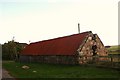
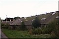
Roadside disrepair
Located between Cairnfechel and North Coullie this smallholding building is in need of more than a little TLC.
Image: © Andrew Wood
Taken: 3 Oct 2008
0.03 miles
3
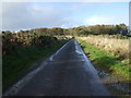
National Cycle Route 1
Heading west near Cairnfechel.
Image: © JThomas
Taken: 10 Nov 2013
0.08 miles
5
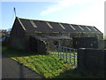
North Coullie
A working farm but as ever these days a little worse for wear.
Image: © Andrew Wood
Taken: 3 Oct 2008
0.14 miles