IMAGES TAKEN NEAR TO
Udny, ELLON, AB41 6QS
Introduction
This page details the photographs taken nearby to AB41 6QS by members of the Geograph project.
The Geograph project started in 2005 with the aim of publishing, organising and preserving representative images for every square kilometre of Great Britain, Ireland and the Isle of Man.

There are currently over 7.5m images from over14,400 individuals and you can help contribute to the project by visiting https://www.geograph.org.uk
Image Map
Images are licensed for reuse under creativecommons.org/licenses/by-sa/2.0
Notes
- Clicking on the map will re-center to the selected point.
- The higher the marker number, the further away the image location is from the centre of the postcode.
Image Listing (5 Images Found)
Images are licensed for reuse under creativecommons.org/licenses/by-sa/2.0
Image
Details
Distance
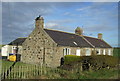
1
Fiddesbeg from the north-east
A distant view of the farm at Fiddesbeg, viewed from the road to the north-east.
Image: © Scott Cormie
Taken: 18 Jul 2023
0.04 miles
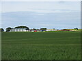
2
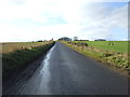
Approaching the T-junction at Fiddesbeg
Image: © David Purchase
Taken: 14 Jun 2019
0.09 miles
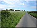
3
Road to Mill of Minnes
The road between Fiddesbeg and Mill of Minnes.
Image: © Andrew Wood
Taken: 8 Aug 2011
0.12 miles
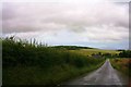
4
Country road, Fiddesbeg
Heading south west.
Image: © JThomas
Taken: 10 Nov 2013
0.21 miles