IMAGES TAKEN NEAR TO
Logierieve, ELLON, AB41 6PS
Introduction
This page details the photographs taken nearby to AB41 6PS by members of the Geograph project.
The Geograph project started in 2005 with the aim of publishing, organising and preserving representative images for every square kilometre of Great Britain, Ireland and the Isle of Man.

There are currently over 7.5m images from over14,400 individuals and you can help contribute to the project by visiting https://www.geograph.org.uk
Image Map
Images are licensed for reuse under creativecommons.org/licenses/by-sa/2.0
Notes
- Clicking on the map will re-center to the selected point.
- The higher the marker number, the further away the image location is from the centre of the postcode.
Image Listing (10 Images Found)
Images are licensed for reuse under creativecommons.org/licenses/by-sa/2.0
Image
Details
Distance
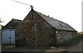
3
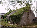
Derelict farm cottage, Logiemuir, nr Pitmedden
Image: © Lynette and Malcolm Johnson
Taken: 4 Aug 2006
0.07 miles
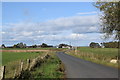
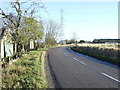
5
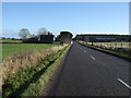
B9000 towards Newburgh at Logierieve
Heading east.
Image: © JThomas
Taken: 10 Nov 2013
0.12 miles
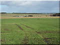
6
Mosstown Farm
On the Mill of Torry road from Logierieve.
Image: © Andrew Wood
Taken: 14 Oct 2008
0.19 miles
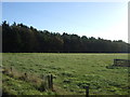
8
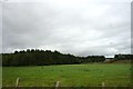
Logierieve Wood
The wood at Logierieve bisected by the old rail line, now a pathway.
Image: © Andrew Wood
Taken: 29 Aug 2011
0.22 miles
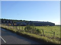
9
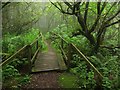
Logierieve Wood
Woodland surrounds the site of Logierieve Station on the Formartine and Buchan Railway.
Image: © Richard Webb
Taken: 4 Aug 2011
0.23 miles
10
B9000 heading east past Tillyfar
Towards Newburgh.
Image: © JThomas
Taken: 10 Nov 2013
0.25 miles