IMAGES TAKEN NEAR TO
Mallard Court, ELLON, AB41 6FJ
Introduction
This page details the photographs taken nearby to Mallard Court, AB41 6FJ by members of the Geograph project.
The Geograph project started in 2005 with the aim of publishing, organising and preserving representative images for every square kilometre of Great Britain, Ireland and the Isle of Man.

There are currently over 7.5m images from over14,400 individuals and you can help contribute to the project by visiting https://www.geograph.org.uk
Image Map
Images are licensed for reuse under creativecommons.org/licenses/by-sa/2.0
Notes
- Clicking on the map will re-center to the selected point.
- The higher the marker number, the further away the image location is from the centre of the postcode.
Image Listing (61 Images Found)
Images are licensed for reuse under creativecommons.org/licenses/by-sa/2.0
Image
Details
Distance
1
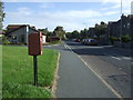
Main Street (A975), Newburgh
Showing position of Postbox No. AB41 254.
See Image] for postbox.
Image: © JThomas
Taken: 21 Aug 2020
0.06 miles
2

Elizabethan postbox on Main Street, Newburgh
Postbox No. AB41 254.
See Image] for context.
Image: © JThomas
Taken: 21 Aug 2020
0.06 miles
3
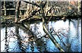
Culterty pond
A wildfowl facility in the grounds of the University of Aberdeen's Culterty research centre.
Image: © Stanley Howe
Taken: Unknown
0.08 miles
4
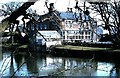
Culterty House, Newburgh (1978)
A 'grace and favour' home for the Regius Professor of Natural History at the University of Aberdeen in the 1970s. The pond was part of the adjacent Research Centre facilities.
Image: © Stanley Howe
Taken: Unknown
0.09 miles
5
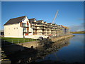
Town houses on the old quay at Newburgh.
New town houses approaching completion on the old quay at Newburgh. They enjoy fabulous views over the lower reaches of the Ythan Estuary.
Image: © Martyn Gorman
Taken: 14 Nov 2007
0.10 miles
6

New townhouses at Newburgh
New townhouses being built on the quay at Newburgh. They replace an old granary and mill on the bank of the Ythan estuary which had exported grain and imported coal for at least 200 years.
Image: © Martyn Gorman
Taken: 26 Apr 2007
0.10 miles
8
Newburgh: The Oceanlab facility
Oceanlab is an Aberdeen University facility to support research in the deep sea. The two buildings have "living" roofs covered in sedum and provide office and engineering facilities. The team based at Oceanlab fabricate devices that can descend to the bottom of the world's deepest oceans where they carry out cutting edge chemical and biological experiments. The buildings in the background are residential houses.
Image: © Martyn Gorman
Taken: 8 May 2009
0.11 miles
9
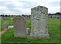
Sea-farers' graves in Holyrood Graveyard
These 2 stones belonging to the Stephen family show the risks faced by sailors. The left-hand stone was erected by Robert Stephen, shipmaster of Newborough, in memory of his wife and family. His daughter, Margaret, died in 1835 aged 4 years, while his three sons were all drowned at sea in 1860 and 1869, aged 23, 17 and 25 years.
This stone shows carved symbols which are appropriate for a seafaring family, including the sun and moon, the Pole Star, several smaller stars and some navigation aids. Religious symbols include an open bible, a deid bell and a coffin on its side, thought to portray untimely deaths.
The other stone remembers shipmaster William Stephen. All of this family lived into their 70s or 80s.
Image gives more information about the burial ground.
Image: © Mary and Angus Hogg
Taken: 24 Aug 2019
0.12 miles
10
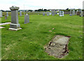
In Holyrood Graveyard, Newburgh
The very old grave-slab in the foreground is dated 1752 but it’s impossible to make out any more information. The carved panel shows the symbols of man’s mortality – the open bible, the hour glass, the skull and crossed bones, a deid bell and a coffin.
Image: © Mary and Angus Hogg
Taken: 24 Aug 2019
0.12 miles