IMAGES TAKEN NEAR TO
Newburgh, ELLON, AB41 6AH
Introduction
This page details the photographs taken nearby to AB41 6AH by members of the Geograph project.
The Geograph project started in 2005 with the aim of publishing, organising and preserving representative images for every square kilometre of Great Britain, Ireland and the Isle of Man.

There are currently over 7.5m images from over14,400 individuals and you can help contribute to the project by visiting https://www.geograph.org.uk
Image Map
Images are licensed for reuse under creativecommons.org/licenses/by-sa/2.0
Notes
- Clicking on the map will re-center to the selected point.
- The higher the marker number, the further away the image location is from the centre of the postcode.
Image Listing (3 Images Found)
Images are licensed for reuse under creativecommons.org/licenses/by-sa/2.0
Image
Details
Distance
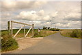
1
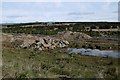
Fornety
Former farm, now woodland. This is a common change of land use in this area. The earthworks are part of the Aberdeen Western Peripheral Route's Foveran bypass which was under construction.
Image: © Richard Webb
Taken: 6 Apr 2017
0.02 miles
2
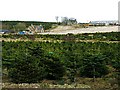
Fornety
In the foreground is a plantation of what look like Christmas trees - Norway Spruce - many of which have a green or blue plastic tag attached to their leading shoot. Houses at Fornety in the background.
Image: © Anne Burgess
Taken: 22 Feb 2009
0.02 miles