IMAGES TAKEN NEAR TO
STONEHAVEN, AB39 3XJ
Introduction
This page details the photographs taken nearby to AB39 3XJ by members of the Geograph project.
The Geograph project started in 2005 with the aim of publishing, organising and preserving representative images for every square kilometre of Great Britain, Ireland and the Isle of Man.

There are currently over 7.5m images from over14,400 individuals and you can help contribute to the project by visiting https://www.geograph.org.uk
Image Map
Images are licensed for reuse under creativecommons.org/licenses/by-sa/2.0
Notes
- Clicking on the map will re-center to the selected point.
- The higher the marker number, the further away the image location is from the centre of the postcode.
Image Listing (7 Images Found)
Images are licensed for reuse under creativecommons.org/licenses/by-sa/2.0
Image
Details
Distance
1
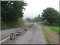
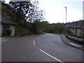
Uphill on National Cycle Route 1
Heading out of Stonehaven.
Image: © JThomas
Taken: 11 Nov 2013
0.20 miles
2
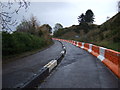
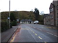
The closed former A92, Stonehaven
Only open to non powered traffic because the hillside below failed during the rain/landslide events of 2004.
Image: © Richard Webb
Taken: 3 Aug 2011
0.21 miles
4
Uphill on National Cycle Route 1
Heading out of Stonehaven.
Image: © JThomas
Taken: 11 Nov 2013
0.23 miles
6
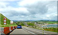
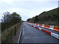
Coastal Tourist Route Stonehaven
Single lane one way only road, providing a magnificent panoramic view of Stonehaven.
Image: © Alex Passmore
Taken: 1 Jun 2019
0.24 miles
7
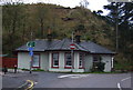
Dunnottar Avenue, Stonehaven (A957)
Heading south.
Image: © JThomas
Taken: 11 Nov 2013
0.25 miles