IMAGES TAKEN NEAR TO
Slug Road, STONEHAVEN, AB39 3SZ
Introduction
This page details the photographs taken nearby to Slug Road, AB39 3SZ by members of the Geograph project.
The Geograph project started in 2005 with the aim of publishing, organising and preserving representative images for every square kilometre of Great Britain, Ireland and the Isle of Man.

There are currently over 7.5m images from over14,400 individuals and you can help contribute to the project by visiting https://www.geograph.org.uk
Image Map
Images are licensed for reuse under creativecommons.org/licenses/by-sa/2.0
Notes
- Clicking on the map will re-center to the selected point.
- The higher the marker number, the further away the image location is from the centre of the postcode.
Image Listing (14 Images Found)
Images are licensed for reuse under creativecommons.org/licenses/by-sa/2.0
Image
Details
Distance
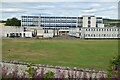
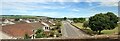
1
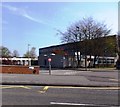
Mackie Academy, Stonehaven
Seen from A957.
Image: © Stanley Howe
Taken: 28 Apr 2014
0.07 miles
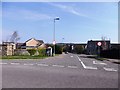
4
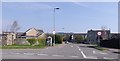
Access to William Mackie Road, Stonehaven
From the Slug Road (A957).
Image: © Stanley Howe
Taken: 28 Apr 2014
0.09 miles
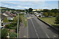
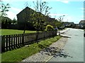
5
Junction of William Mackie Road with A957
Speed limited to 20mph through this residential area adjacent to Mackie Academy (off R).
Image: © Stanley Howe
Taken: 28 Apr 2014
0.10 miles
8
Glenury Rail Viaduct
Seen from near the old Distillery.
Image: © Stanley Howe
Taken: 27 Dec 2006
0.18 miles
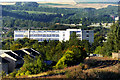
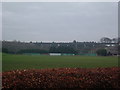
9
New homes on the Stonehaven fringe
Several new homes have appeared at the northwestern outskirts of Stonehaven since publication of the last OS map.
Image: © C Michael Hogan
Taken: 6 Jul 2013
0.18 miles
10
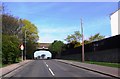
Main-line rail bridge over A957 in Stonehaven
Between the Glenury Viaduct (of R) and Stonehaven Station (off L).
Image: © Stanley Howe
Taken: 28 Apr 2014
0.19 miles