IMAGES TAKEN NEAR TO
Rickarton, STONEHAVEN, AB39 3SY
Introduction
This page details the photographs taken nearby to AB39 3SY by members of the Geograph project.
The Geograph project started in 2005 with the aim of publishing, organising and preserving representative images for every square kilometre of Great Britain, Ireland and the Isle of Man.

There are currently over 7.5m images from over14,400 individuals and you can help contribute to the project by visiting https://www.geograph.org.uk
Image Map
Images are licensed for reuse under creativecommons.org/licenses/by-sa/2.0
Notes
- Clicking on the map will re-center to the selected point.
- The higher the marker number, the further away the image location is from the centre of the postcode.
Image Listing (8 Images Found)
Images are licensed for reuse under creativecommons.org/licenses/by-sa/2.0
Image
Details
Distance
1
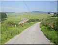
Union Cottage ahead
Nether Auquhollie top right.
Image: © Stanley Howe
Taken: 2 Jul 2009
0.08 miles
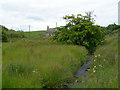
2

Rumbleyond Burn
A minor bridge on the Rumbleyond Burn near Union cottage used mainly for farm vehicles on the Rickarton Estate
Image: © Liz Gray
Taken: 29 Jul 2013
0.09 miles
3

Estate road at Union Cottage
The estate track that leads from Union Cottage through Auquhollie Wood to Rumbleyond, a track used mainly by agricultural vehicles
Image: © Liz Gray
Taken: 29 Jul 2013
0.09 miles
4
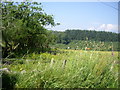
Soggy banks of Cowton Burn
The photographer is standing on the very soft deep grass banks of Cowton Burn looking upstream toward the old mill and locus of the minor bridge crossing.
Image: © C Michael Hogan
Taken: 20 Jul 2007
0.12 miles
5
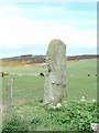
Lang Stane
This stone has what is known as an Ogham Inscription on it an ancient
Irish alphabet from the fourth or fifth century
Image: © Alan Thomson
Taken: 14 May 2006
0.16 miles
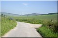
6
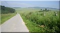
Road to Nether Auquhollie
Nether Auquhollie at top right.
Image: © Stanley Howe
Taken: 2 Jul 2009
0.16 miles
8
Junction for West Raedykes
Off Cowton to Auquhollie road.
Image: © Stanley Howe
Taken: 2 Jul 2009
0.25 miles