IMAGES TAKEN NEAR TO
Muchalls, STONEHAVEN, AB39 3RS
Introduction
This page details the photographs taken nearby to AB39 3RS by members of the Geograph project.
The Geograph project started in 2005 with the aim of publishing, organising and preserving representative images for every square kilometre of Great Britain, Ireland and the Isle of Man.

There are currently over 7.5m images from over14,400 individuals and you can help contribute to the project by visiting https://www.geograph.org.uk
Image Map
Images are licensed for reuse under creativecommons.org/licenses/by-sa/2.0
Notes
- Clicking on the map will re-center to the selected point.
- The higher the marker number, the further away the image location is from the centre of the postcode.
Image Listing (5 Images Found)
Images are licensed for reuse under creativecommons.org/licenses/by-sa/2.0
Image
Details
Distance
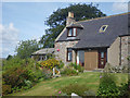
2
Back road to Muchalls Castle
From near Montgatehead.
Image: © Stanley Howe
Taken: 14 Mar 2007
0.16 miles
3
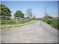
Road to Blackbutts
From the minor road between Bridge of Muchalls and Netherley.
Image: © Stanley Howe
Taken: 6 Jun 2013
0.19 miles
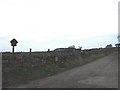
4
A conservation stone wall between fields
North of the minor road between Bridge of Muchalls and Netherley.
Image: © Stanley Howe
Taken: 6 Jun 2013
0.21 miles
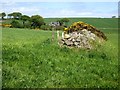
5
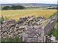
Ruined Episcopalian Chapel
This is the chapel where the noted Reverend John Troup administered to his congregation in the 1700s, becoming imprisoned at the Stonehaven Tolbooth during the Episcopal suppression during the Jacobite uprisings. The chapel is situated on lands historically owned by Muchalls Castle.
Image: © C Michael Hogan
Taken: 8 Aug 2006
0.21 miles