IMAGES TAKEN NEAR TO
Muchalls, STONEHAVEN, AB39 3RQ
Introduction
This page details the photographs taken nearby to AB39 3RQ by members of the Geograph project.
The Geograph project started in 2005 with the aim of publishing, organising and preserving representative images for every square kilometre of Great Britain, Ireland and the Isle of Man.

There are currently over 7.5m images from over14,400 individuals and you can help contribute to the project by visiting https://www.geograph.org.uk
Image Map
Images are licensed for reuse under creativecommons.org/licenses/by-sa/2.0
Notes
- Clicking on the map will re-center to the selected point.
- The higher the marker number, the further away the image location is from the centre of the postcode.
Image Listing (31 Images Found)
Images are licensed for reuse under creativecommons.org/licenses/by-sa/2.0
Image
Details
Distance
1
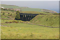
Toadhall, Nr Bridge of Muchalls
Taken from a passing train heading towards Aberdeen.
Image: © Carl Farnell
Taken: 11 Dec 2006
0.06 miles
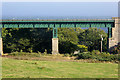
2
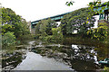
Pond and Viaduct
A small pond lies in the shadow of the viaduct carrying the railway line to Aberdeen.
Image: © Anne Burgess
Taken: 21 Sep 2019
0.06 miles
3
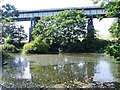
Railway viaduct crosses the Burn of Muchalls
Image: © Tim Glover
Taken: 6 Sep 2010
0.06 miles
4
Railway bridge at Bridge of Muchalls
Image: © Mike Pennington
Taken: 3 Jun 2011
0.06 miles
5
Railway Viaduct over the Burn of Muchalls
Image: © David Dixon
Taken: 19 Sep 2018
0.06 miles
6
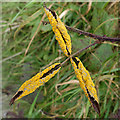
Bramble Rust
The yellow spots on these bramble leaves are a fungus, possibly Orange Bramble Rust (Phragmidium bulbosum).
Image: © Anne Burgess
Taken: 21 Sep 2019
0.08 miles
7
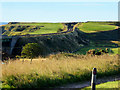
Coastal Railway near Bridge of Muchalls
Image: © David Dixon
Taken: 24 Sep 2018
0.08 miles
8
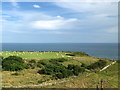
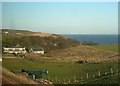
Farmland leading to cliffs at Easter Muchalls
Image: © David Robinson
Taken: 24 Jul 2019
0.10 miles
9
Burn of Muchalls
The burn flows through a tranquil pool in the hollow here among the whins before disappearing over the edge of the cliff in a waterfall.
Image: © Anne Burgess
Taken: 13 May 2010
0.11 miles
10
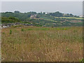
Drystone ruins beyond wildflower meadow
The homes in the background are on the Grim Brigs headland and at the coastal verge of the village of Muchalls.
Image: © C Michael Hogan
Taken: 26 Jul 2008
0.13 miles