IMAGES TAKEN NEAR TO
Netherley, STONEHAVEN, AB39 3QN
Introduction
This page details the photographs taken nearby to AB39 3QN by members of the Geograph project.
The Geograph project started in 2005 with the aim of publishing, organising and preserving representative images for every square kilometre of Great Britain, Ireland and the Isle of Man.

There are currently over 7.5m images from over14,400 individuals and you can help contribute to the project by visiting https://www.geograph.org.uk
Image Map
Images are licensed for reuse under creativecommons.org/licenses/by-sa/2.0
Notes
- Clicking on the map will re-center to the selected point.
- The higher the marker number, the further away the image location is from the centre of the postcode.
Image Listing (3 Images Found)
Images are licensed for reuse under creativecommons.org/licenses/by-sa/2.0
Image
Details
Distance
1
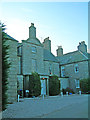
Netherley House
The stonework of this historic mansion is readily recognisable by comparison to historic photography dating to about 100 years ago; however, the forest has encroached on the home during the last century making a full width photo virtually impossible. The mansion was built by the Silver family, who earned their fortune in the East India trade.
Image: © C Michael Hogan
Taken: 25 Oct 2007
0.01 miles
2
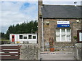
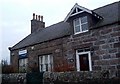
Netherley School, Aberdeenshire
A small school found in the hamlet of Netherley.
The school has 32 pupils according to this web page
http://atschool.eduweb.co.uk/netherley.pr/
Image: © Lizzie
Taken: 26 Jul 2005
0.20 miles