IMAGES TAKEN NEAR TO
Muchalls, STONEHAVEN, AB39 3PN
Introduction
This page details the photographs taken nearby to AB39 3PN by members of the Geograph project.
The Geograph project started in 2005 with the aim of publishing, organising and preserving representative images for every square kilometre of Great Britain, Ireland and the Isle of Man.

There are currently over 7.5m images from over14,400 individuals and you can help contribute to the project by visiting https://www.geograph.org.uk
Image Map
Images are licensed for reuse under creativecommons.org/licenses/by-sa/2.0
Notes
- Clicking on the map will re-center to the selected point.
- The higher the marker number, the further away the image location is from the centre of the postcode.
Image Listing (11 Images Found)
Images are licensed for reuse under creativecommons.org/licenses/by-sa/2.0
Image
Details
Distance
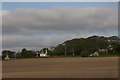
1
Looking north along the Causey Mounth to Nether Cairnhill
The photograph looks across a ford of the Pheppie Burn.
Image: © C Michael Hogan
Taken: 3 Jul 2007
0.03 miles
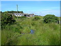
2
Farm road near A90
The junction of the narrow public road and the farm road to Nether Cairnhill (farm road is the one that leads to the trees in this shot). The A90 dual-carriageway could be heard from this junction.
Image: © Steven Brown
Taken: 21 Jul 2007
0.08 miles
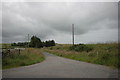
3
Field beside the Chapel
The view north from St Ternan's Chapel. The field and the road, marked by the intermittent line of whins, are in this square.
Image: © Anne Burgess
Taken: 30 Mar 2015
0.14 miles
4
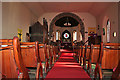
St Ternan's Episcopal Church Nave and Chancel
The nave and chancel. For a fuller description of the chapel see Image],
Image: © Anne Burgess
Taken: 30 Mar 2015
0.20 miles
5
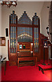
St Ternan's Episcopal Church Organ
For a description of the chapel see Image
Image: © Anne Burgess
Taken: 30 Mar 2015
0.20 miles
6
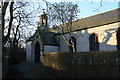
St Ternan's Episcopal Church
The 'Episcopal Chapel at Muchalls' dated from at least the early 17th century. After the Reformation and the adoption of Presbyterianism as the principal form of church in Scotland, one of the strongholds of Episcopalianism was in the north and north-east of the country, notably Angus, Kincardineshire and Aberdeenshire, and was usually associated with support for the Jacobite cause after 1688. Many congregations survived despite official disapproval and sometimes persecution. In 1713 an Act of Toleration permitted Episcopalians freedom of worship provided they ceased to support the Jacobites, but in 1746, at the height of the last Jacobite Rising, many Episcopalian churches and chapels were burned down, including the original one at Muchalls. A temporary chapel was built in 1748, rebuilt in 1770, replaced in 1795 and finally abandoned about 1830 when a new chapel was built on this site. This is the centre section of the present building. It was later lengthened, and the chancel was added in 1865, when the name St Ternan's was adopted. For a fuller history see http://www.stternans.co.uk/page2.htm
Image: © Anne Burgess
Taken: 30 Mar 2015
0.20 miles
7
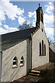
St Ternan's Episcopal Church East Gable
This gable dates from the extension of the nave in the first half of the 19th century, and the lean-to is a still later addition. For a fuller description of the chapel see Image
Image: © Anne Burgess
Taken: 30 Mar 2015
0.21 miles
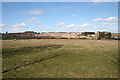
8
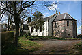
Church near Muchalls
St Ternan's episcopal church, the oldest church in the Brechin diocese, built 1831-70.
Image: © Colin Kinnear
Taken: 2 Mar 2011
0.21 miles
9
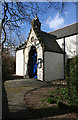
St Ternan's Episcopal Church
This is the main door of the chapel, presumably added when the nave was extended. See Image] for a fuller description of the chapel.
Image: © Anne Burgess
Taken: 30 Mar 2015
0.21 miles