IMAGES TAKEN NEAR TO
Newtonhill, STONEHAVEN, AB39 3NU
Introduction
This page details the photographs taken nearby to AB39 3NU by members of the Geograph project.
The Geograph project started in 2005 with the aim of publishing, organising and preserving representative images for every square kilometre of Great Britain, Ireland and the Isle of Man.

There are currently over 7.5m images from over14,400 individuals and you can help contribute to the project by visiting https://www.geograph.org.uk
Image Map
Images are licensed for reuse under creativecommons.org/licenses/by-sa/2.0
Notes
- Clicking on the map will re-center to the selected point.
- The higher the marker number, the further away the image location is from the centre of the postcode.
Image Listing (4 Images Found)
Images are licensed for reuse under creativecommons.org/licenses/by-sa/2.0
Image
Details
Distance
1
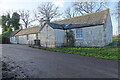
East Quoscies
A traditional stone cottage, the far end swathed in ivy.
Image: © Anne Burgess
Taken: 1 Jan 2022
0.00 miles
2
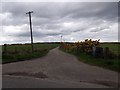
Track to Beltcraigs
Off minor road from A90 to Lairhillock.
Image: © Stanley Howe
Taken: 6 May 2014
0.16 miles
3
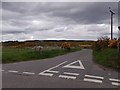
Wedderhill junction
Off minor road to Lairhillock.
Image: © Stanley Howe
Taken: 6 May 2014
0.16 miles
4
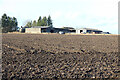
Quoscies Farm
Viewed across a recently ploughed field.
Image: © Anne Burgess
Taken: 1 Jan 2022
0.17 miles