IMAGES TAKEN NEAR TO
Cammachmore, STONEHAVEN, AB39 3NR
Introduction
This page details the photographs taken nearby to AB39 3NR by members of the Geograph project.
The Geograph project started in 2005 with the aim of publishing, organising and preserving representative images for every square kilometre of Great Britain, Ireland and the Isle of Man.

There are currently over 7.5m images from over14,400 individuals and you can help contribute to the project by visiting https://www.geograph.org.uk
Image Map
Images are licensed for reuse under creativecommons.org/licenses/by-sa/2.0
Notes
- Clicking on the map will re-center to the selected point.
- The higher the marker number, the further away the image location is from the centre of the postcode.
Image Listing (7 Images Found)
Images are licensed for reuse under creativecommons.org/licenses/by-sa/2.0
Image
Details
Distance
1

Undulating fields with urban development beyond
The urban development in the background is associated with the A90 dual carriageway.
Image: © C Michael Hogan
Taken: 4 Jul 2007
0.01 miles
3
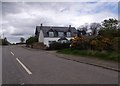
Cammies Inn, Cammachmore
Near Newtonhill, on the former main road from Stonehaven to Aberdeen (now bypassed by A90 dual carriageway).
Image: © Stanley Howe
Taken: 6 May 2014
0.17 miles
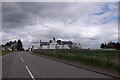
4
New Cammach Inn, Cammachmore
The inn is now closed.
Image: © Dominic Dawn Harry and Jacob Paterson
Taken: 24 Mar 2006
0.19 miles
5
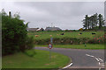
Junction at Cammachmore, near Portleithen
Image: © Mike Pennington
Taken: 29 May 2017
0.19 miles
6
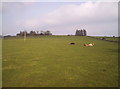
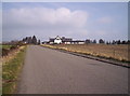
4 Cows and a Field
A very large field for 2 cows and 2 calfs with the farm buildings in the background.
Image: © Dominic Dawn Harry and Jacob Paterson
Taken: 24 Mar 2006
0.22 miles
7
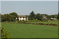
House and fields north of Newtonhill
Image: © Mike Pennington
Taken: 3 Jun 2011
0.23 miles