IMAGES TAKEN NEAR TO
Cliff View, STONEHAVEN, AB39 3GX
Introduction
This page details the photographs taken nearby to Cliff View, AB39 3GX by members of the Geograph project.
The Geograph project started in 2005 with the aim of publishing, organising and preserving representative images for every square kilometre of Great Britain, Ireland and the Isle of Man.

There are currently over 7.5m images from over14,400 individuals and you can help contribute to the project by visiting https://www.geograph.org.uk
Image Map
Images are licensed for reuse under creativecommons.org/licenses/by-sa/2.0
Notes
- Clicking on the map will re-center to the selected point.
- The higher the marker number, the further away the image location is from the centre of the postcode.
Image Listing (4 Images Found)
Images are licensed for reuse under creativecommons.org/licenses/by-sa/2.0
Image
Details
Distance
1
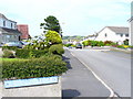
Park Place, Newtonhill
Residential street of modern housing on the southern edge of Newtonhill, a dormitory village for Aberdeen.
Image: © Colin Smith
Taken: 5 Aug 2009
0.16 miles
3

Newtonhill parish church
This modest structure dates from 1987.
Image: © Bill Harrison
Taken: 24 Mar 2018
0.21 miles
4
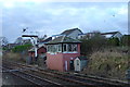
Newtonhill Signal Box
Still in daily use, this signal box sits alongside the main line between Dundee and Aberdeen. There was once a station at Newtonhill, but since the fishing industry died, there has been no need for freight to be taken from Newtonhill, and the village has not yet justified a new station. Maybe one day...!
Image: © Iain Millar
Taken: 27 Dec 2005
0.23 miles